Ground Penetrating Radar (GPR) is an effective technology for locating non-conductive utilities and underground anomalies. Safe for use in public spaces and a wider variety of project sites, it is best leveraged when non-metallic utilities are assumed to reside in the project area, such as:
- plastic conduits
- fibre optic cables
- utility ducts
- water pipes
- concrete sewer lines
- foundation, chambers, and tunnels
Enhance Ground Penetrating Radar (GPR) utility data and mapping
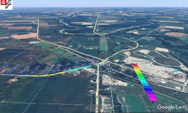
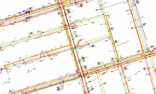
GPR data can yield a cross-section of subsurface utilities and depict three-dimensionally in the right conditions to provide data on the estimated depth of utilities. This data can then be integrated with information generated from Electromagnetic (EM) Induction techniques to deliver a more complete picture of subsurface utilities and highlight conflicting information.
How does Ground Penetrating Radar (GPR) work?
GPR is a non-destructive technology that transmits high-frequency radio waves into the ground or structure, analyzing the reflected energy to create a profile of subsurface features. The reflections are caused by a contrast in the electrical properties of subsurface materials. This is usually indicative of changes in lithology, water content, void spaces in the ground, rebar or post tension cable corrosion, asphalt deterioration, or made features such as foundations, pipes and cables, storage tanks, graves, and other objects.
The radio wave transmits at regular intervals as the GPR unit travels along a survey line. For each transmitted pulse, the resulting reflected energy from the subsurface is recorded and manifested as a single radar trace. These individual traces are stacked side by side as the data is collected to build up a cross-sectional image or profile of the subsurface.
High-frequency Ground Penetrating Radar
High-frequency GPR antennas (1000 MHz or greater) are commonly used for scanning concrete structures to detect the location of embedded structural elements (rebar, post-tensioned cables, beams) and embedded utilities (primarily electrical lines, telecom/security cabling). Maximum penetration depth in concrete is generally in the 12-16” range (30-40 cm) for the 1000 MHz system. If slabs are greater than 16”, scanning from both sides may be necessary or a lower frequency technology may be used.
Applications for High-frequency GPR include:
- Cutting and coring applications (safety, object avoidance)
- Detecting defects in concrete structures (delamination, cracks, voids, spalling)
- Indoor utility detection and mapping
- Detecting voids below concrete floors
Medium-frequency Ground Penetrating Radar
Medium-frequency GPR antennas (500-250 MHz) generally reach a penetration depth of 40cm-3m. Units within this range are commonly used for subsurface mapping and utility locating. These systems provide the optimal balance between depth of penetration and resolution. Resolution refers to how close interfaces can be to one another and still be identified as separate interfaces.
Applications for Medium-frequency GPR include:
- Subsurface Utility Mapping (SUM)
- Archaeology
- Forensics
Low-frequency Ground Penetrating Radar
Low-frequency GPR antennas (250 MHz or lower) are generally used for geologic investigations and for finding large structures buried at depths greater than 3m. The targets are either laterally extensive, flat-lying to sub-horizontal reflectors such as bedrock interfaces, stratigraphic horizons, or large structures such as industrial process pipes and sewers. The equipment for these survey applications is modular and can be moved manually in rough terrain or mounted on a cart in smoother terrain.
Applications for Low-frequency GPR include:
- Geologic mapping
- Geotechnical applications (underground storage tank or UST detection)
- Deep Subsurface Utility Mapping (SUM)
We’re experienced Ground Penetrating Radar experts
multiVIEW expert technicians have the experience and latest training required for diligent equipment selection, data capturing, software analysis, reporting, and communicating results. We are the trusted “go-to” industry experts and are capable of handling any task of any sized utility locating, subsurface utility engineering, concrete scanning, or bridge and road inspection project.