Background
An engineering firm retained multiVIEW to perform a geophysical survey. The primary objective of the survey was to map the spatial position of any buried metallic objects that may occur within the investigation limits.
The secondary objective was to map the spatial position of any anomalous conditions that may exist beneath the existing buildings. The information was used by the engineering firm to assist with their site investigation of the property.
Methodology – Locating Buried Metallic Objects
A survey grid was installed on 5 metre centers across the outdoor survey area using survey tapes, a right-angle prism and line-of-site positioning. The electromagnetic data were acquired at a station spacing of 0.2-metres along lines spaced at 2.0-metre intervals over the entire site, where accessible.
Ground Penetrating Radar (GPR) profiling was conducted to attempt to further characterize any significant EM anomalies, and to scan the entire building interior. GPR data was collected at a line spacing of 1 metre across each survey area, where accessible. All possible anomalies were further profiled in multiple orientations.
Findings
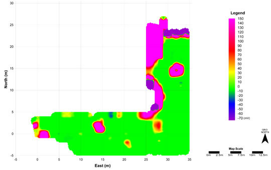
Figures 1 and 2 shows halos of elevated readings evident around the edges of the building, concrete slab, and other metallic surface features. These findings confirmed the presence of buried metallic objects in the project site.
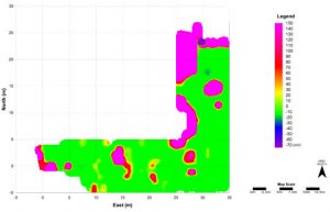

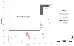
Figure 3 shows multiple EM anomalies that were detected within the survey limits. The EM anomaly locations, descriptions and their respective GPR responses were provided in a summary report.